The Edgewater Underline
To round out my urban studies degree I created a proposal in response to the ongoing CTA renovation of the northern red line. My project stands on three legs: community engagement, infrastructure design, and historical/local representation. I'm striving to understand the local relationships to the tracks and their renovation, improve on the design of several blocks running through the neighborhood, and acknowledge the role the historic tracks played in creating the neighborhood.

Section 1/4, from Irving Park Rd to W Montrose Ave.

Section 2/4, from W Montrose Ave to W Lawrence Ave.

Section 3/4, from W Lawrence Ave to Foster Ave.

Section 4/4, from W Foster Ave. to Bryn Mawr Ave.

Cross section: Wilson Station
This cross section drawing depicts the renovated tracks, the bike lane as it ramps up from Broadway and over the roof of the old station, and the roof as newly activated space populated by the bike path. The infrastructure design I am proposing rests on an idea for a bike path that flies over obstacles and intersections thereby preserving the experience of the biker above all else. During my forays into the neighborhood I observed a very active and experienced bike culture, in response I designed a path that would provide excitement, adventure, and views to the advance bikers in the area.

Key: This is the master key to my master plan, indicating the materials included, bike path inclinations, and registered community centers. The master plan focuses most specifically on the infrastructure design of the bike path and cross streets.

Initial Plan: This is a full map of the stretch of north Chicago that my projects involve. The key details how each intersection will be treated.

Earlier Rendition: This sketch was part of an earlier phase of this project in which I considered sinking the vehicular intersections underground in some places in order to free up the ground level for pedestrians and bikes. This idea was born from my curiosity about the potential of expanding Chicago's underground road system, as well as the time I recently spent in Bologna, IT which routinely closes its downtown to cars.

Lake Shore Trail Connection: Not included in the master plan is a proposed connection between the bike path and the lake shore trail which ends at Melrose beach. This would extend biking possibilities for all the bikers on the trail and connect them into Edgewater.


Art Installation: In order to memorialize the role of the old red line tracks, built in 1916, as well as the life of the community since then, I propose a community run public art installation under the new tracks. The renovated tracks are built with striking concrete pillars, placed 100 meters apart all along the section of track I'm dealing with. I think that muralizing each pillar to represent a subset of the community would create a cohesive, complete, and beautiful memorial to the old red line. Community centers are marked in a purple outline on the master plan, denoting groups to contact to decorate the pillars. To tie this project together I propose assembling a small team of public artists to help execute the community's ideas.

Cross section: This cross section shows the relationships between the different types of infrastructure involved. It illustrates how the bike path might hang from the tracks when crossing intersections, how the trains might interact with the bikers, and how the underneath space is formed by all of this.
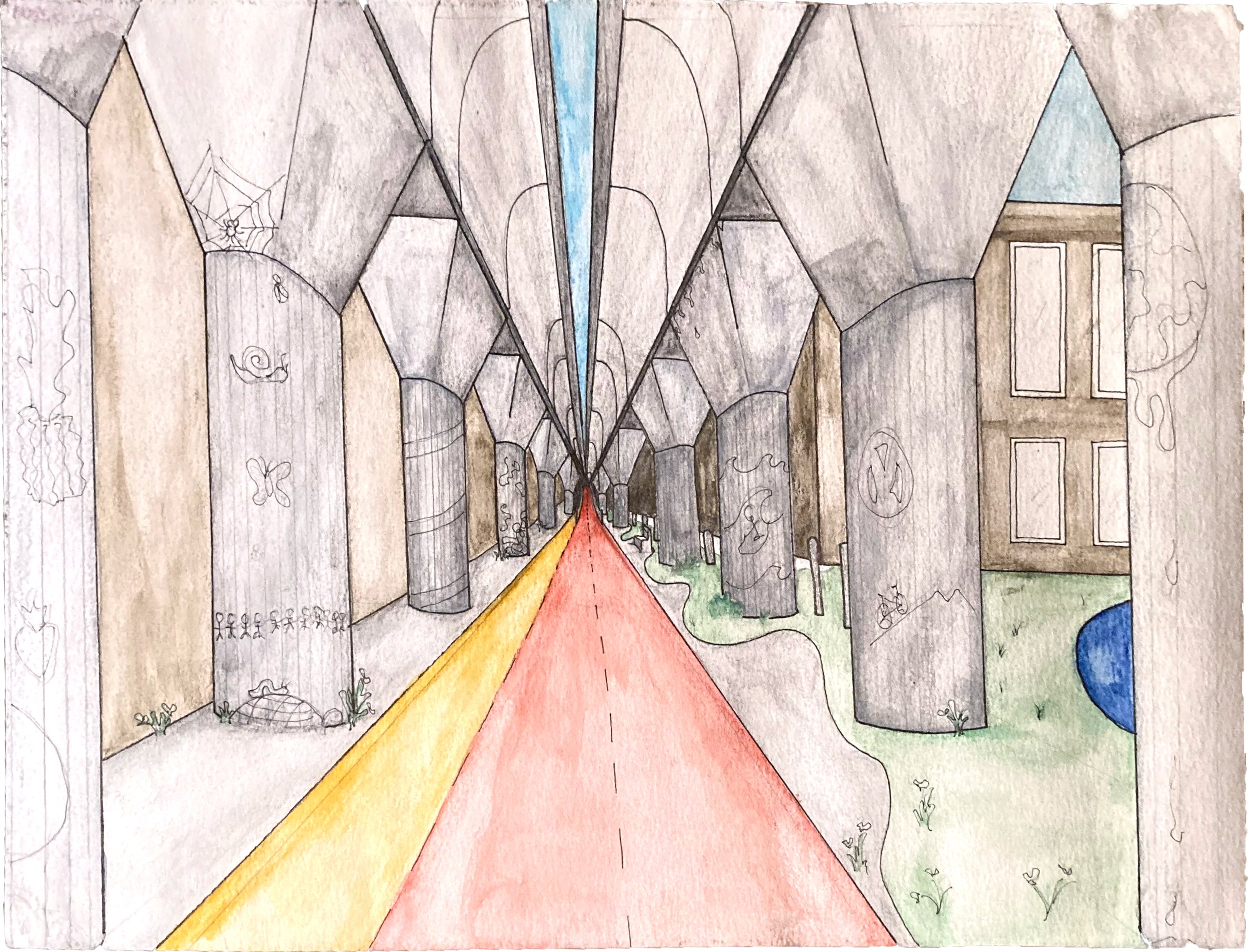
Perspective: This is a perspective shot of the underline as it would look from a bike passing the small playground to the right. In the distance, the bike ramp up to train level is visible, as well as the color-coded biking and walking paths. Pencil sketches show possible permutations of the pillar art installation.
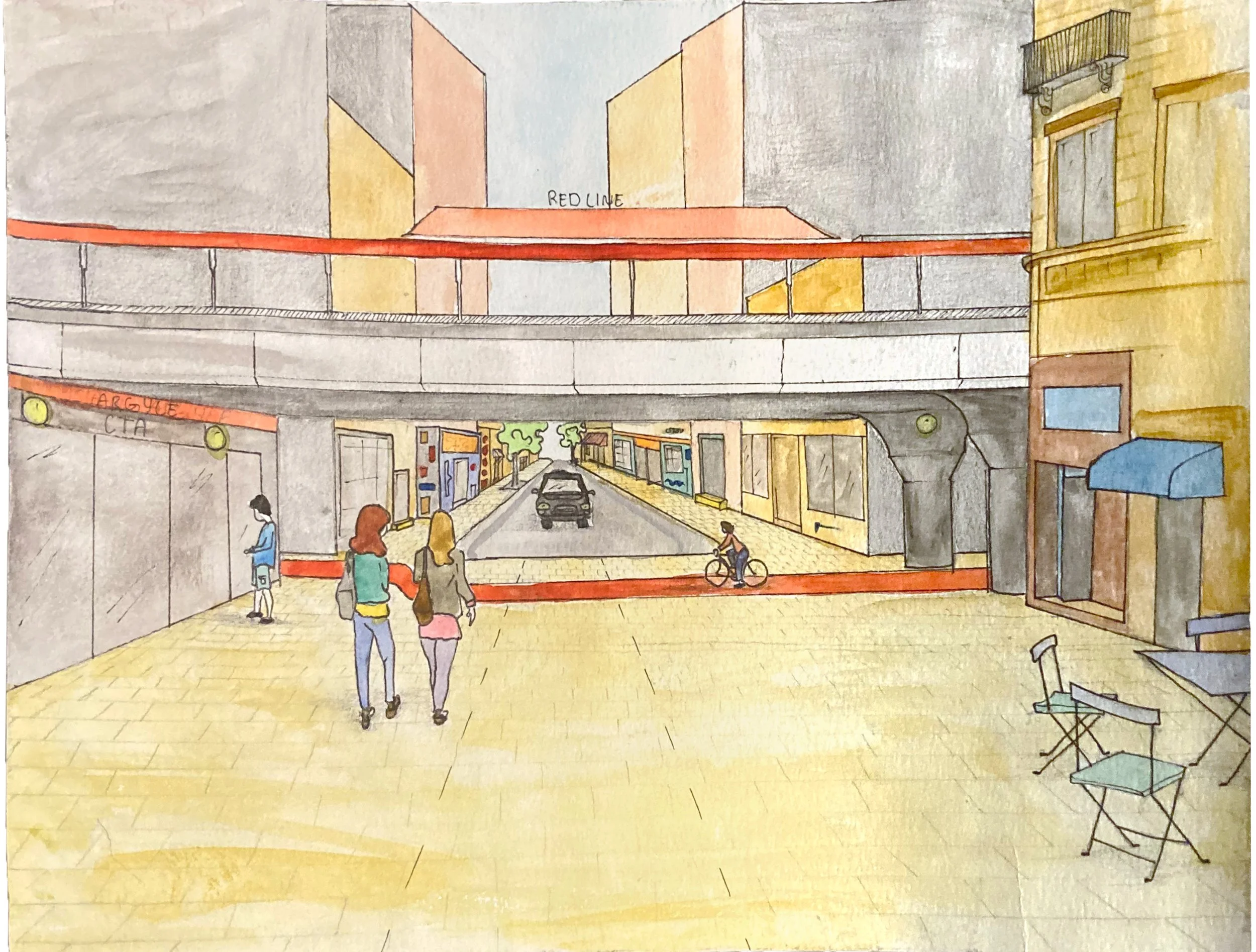
Perspective: This perspective drawing shows a newly renovated Argyle Station and a pedestrianized intersection which avoids the need for an elevated path. This street underwent something similar in 2015 with limited success, I propose delineating the car and pedestrian roads even further and aiming to make drivers feel the least comfortable in this space.